


Filed As:
Boletaceae
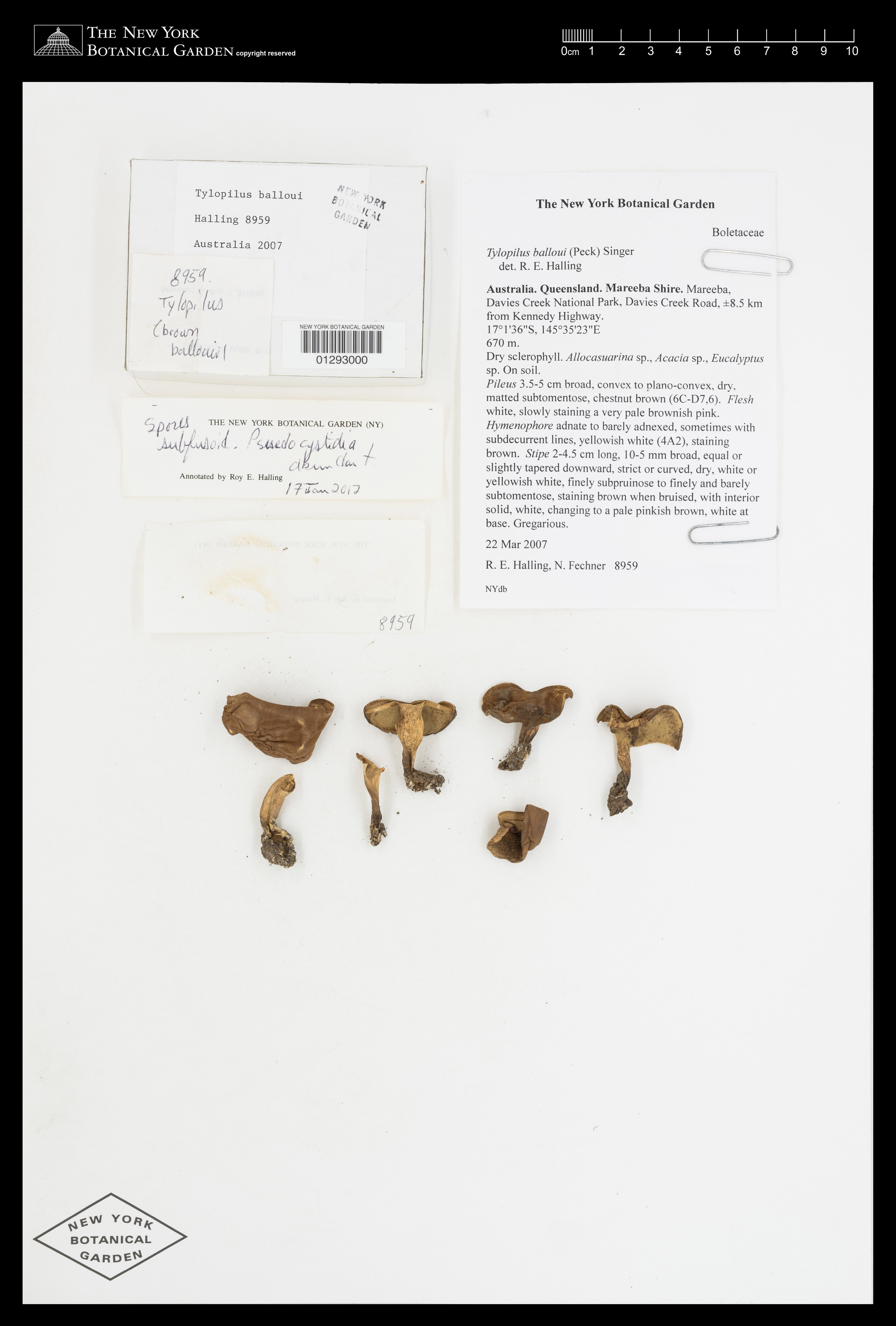
Tylopilus balloui (Peck) Singer s.l.
Boletaceae
Tylopilus balloui (Peck) Singer s.l.
Location:
Australia. Queensland. Mareeba Shire. Mareeba. Davies Creek National Park, Davies Creek Road, ±8.5 km from Kennedy Highway. Alt. 670 m. (2198 ft.)
Australia. Queensland. Mareeba Shire. Mareeba. Davies Creek National Park, Davies Creek Road, ±8.5 km from Kennedy Highway. Alt. 670 m. (2198 ft.)
Description:
Pileus 3.5-5 cm broad, convex to plano-convex, dry, matted subtomentose, chestnut brown (6C-D7,6). Flesh white, slowly staining a very pale brownish pink. Hymenophore adnate to barely adnexed, sometimes with subdecurrent lines, yellowish white (4A2), staining brown. Stipe 2-4.5 cm long, 10-5 mm broad, equal or slightly tapered downward, strict or curved, dry, white or yellowish white, finely subpruinose to finely and barely subtomentose, staining brown when bruised, with interior solid, white, changing to a pale pinkish brown, white at base. Spores fusoid. Hymenial cystidia present as pseudocystidia.
Pileus 3.5-5 cm broad, convex to plano-convex, dry, matted subtomentose, chestnut brown (6C-D7,6). Flesh white, slowly staining a very pale brownish pink. Hymenophore adnate to barely adnexed, sometimes with subdecurrent lines, yellowish white (4A2), staining brown. Stipe 2-4.5 cm long, 10-5 mm broad, equal or slightly tapered downward, strict or curved, dry, white or yellowish white, finely subpruinose to finely and barely subtomentose, staining brown when bruised, with interior solid, white, changing to a pale pinkish brown, white at base. Spores fusoid. Hymenial cystidia present as pseudocystidia.
Habitat:
Dry sclerophyll. Allocasuarina sp., Acacia sp., Eucalyptus sp. Gregarious. On soil.
Dry sclerophyll. Allocasuarina sp., Acacia sp., Eucalyptus sp. Gregarious. On soil.
Other:
Specimen Notes: Duplicate in BRI (AQ0794158)
Specimen Notes: Duplicate in BRI (AQ0794158)
Identifiers:
NY Barcode: 1293000
GUID: 0c10285c-514b-4391-8e9d-18a9807c05f3
NY Barcode: 1293000
GUID: 0c10285c-514b-4391-8e9d-18a9807c05f3
Map:
Georeferencing Method: GPS (The longitude and latitude coordinates are those of Campsite 5-6 (formerly known as Rope Swing Lunch Site in Feb 1992).)
Coordinates: (-17.0267, 145.59)
Georeferencing Method: GPS (The longitude and latitude coordinates are those of Campsite 5-6 (formerly known as Rope Swing Lunch Site in Feb 1992).)
Coordinates: (-17.0267, 145.59)