Sites Module
Locality Tab
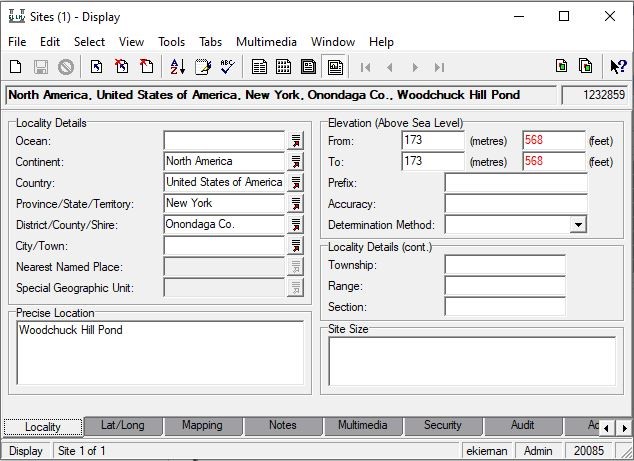
Enter all available geographic information from the specimen label into the appropriate field. Continent, Country, and Province/State/Territory lookup lists are up-to-date and have been locked, meaning that the values in these fields cannot be added to or edited. If a value from a label is not displaying in the drop-down list of one of these fields, the information on the label is outdated, incorrect, or the information is being placed in the incorrect field. Please alternatively enter this data into the Precise Location field (do not omit the data as it needs to be captured). If there is no specific locality description to be placed in the Precise Location field, leave the field empty rather than recording “[no precise location]" or a variation of that phrase in brackets as it is not standard practice. Elevation (when provided) should be entered in the Elevation (Above Sea Level) field(s); if provided in a range, the lower elevation value should be placed in the “From:” field, and the higher elevation value in the “To:” field. Sometimes location information is provided in Township, Range, and Section (TRS) format; place that information in the Locality Details section (below Elevation), ensuring that letters "T", "R", and "S" are included as the prefix before appropriate value/direction (i.e. T10S, R23E, S12).

Example of a filled-out Locality tab
See also Geography Exceptions to the Rule
Mapping Tab
Location information may also be provided in UTM (Universal Transverse Mercator) format, which consists of a zone, an easting value, and a northing value. UTM information should be recorded in the Mapping Tab, UTM field in this format: "UTM: zone easting northing," with spaces separating the values (i.e. “UTM: 12 0520951E 4419038N”). If datum is provided, add at the end of the string after a comma (i.e.“UTM: 12 508473E 4503556, NAD 27”). Occasionally, the zone is not provided. When this happens, please record empty brackets ("[ ]") before the easting and northing value string in the UTM field (i.e. “UTM: [ ] 0520951E 4419038N”). The easting and northing values should also be recorded in the Easting and Northing fields under the Mapping Co-ordinates section.
You may see UTM values recorded in alternate formats, such as “UTM - 508473 m.E by 4503556 m.N (Zone 12, NAD 27”). In instances like this, you should omit the "m." and delete the space between value/direction for each coordinate, and retain the datum inforamtion (NAD27) separated by a comma after the string (=“UTM: 12 508473E 4503556, NAD 27”). Primary contact for questions or concerns: Liz Gjieli, egjieli@nybg.org.

Recording UTM values in the Mapping tab.
Lat/Long Tab
Coordinates provided on label
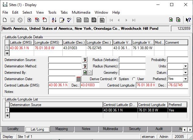
If latitude and longitude coordinates are provided in decimal degrees (-22.00, -42.05) or degrees minutes seconds (22° 00' 29" S, 42° 03' 35" W), input the values in Latitude/Longitude Details field in the appropriate area. EMu automatically converts coordinate values between the two formats, so either format is acceptable. If coordinates are provided in Township, Range, and Section format (TRS), please enter in the “Locality Details (cont.)” section in the Locality Tab (as discussed previously); this information can be translated into decimal degrees using a coordinate conversion calculator at a later time.

How to record geo-coordinates provided on a specimen label in the Lat/Long table.
Coordinates determined by georeferencing locality
For the following fields used for metadata capture, please do your best to use one of the terms provided in the drop-down list. If you are unsure what to record, or if you need information on best practices, please contact Liz Gjieli, egjieli@nybg.org.
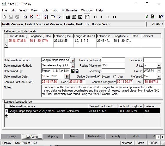
Determination Source: Source of the coordinates, or tools used by the georeferencer to locate the collection site. This includes Google Maps, Google Earth, GeoLocate, MaNIS Georeferencing Calculator, paper maps, gazetteers, etc.
Determination Method: Protocols to determine coordinates. List the georeferencing protocols followed; this is normally a reference guide (Georeferencing Quick Reference Guide, Biogeomancer Guide to Best Practices for Georeferencing, etc.) or an online coordinate conversion tool if coordinates were provided on the label in a format other than decimal degrees or degrees minutes seconds.
Determined By: georeferencer's name (Parties record)
Determination Date: date (short-cut for today's date: CTRL ; )
Radius (Numeric): Uncertainty radius, in meters.
Units: m
Datum: WGS84 (datum used by Google Maps, Google Earth, GeoLocate, Bing Maps, OpenStreetMap, etc.)
Notes: Please enter concise notes on the methods and steps taken to locate coordinates and/or radial for the locality. There is a georeferencing notes template document which provides sample of georeferencing notes to be used per each locality type.

Example of a completed georeferenced Sites record
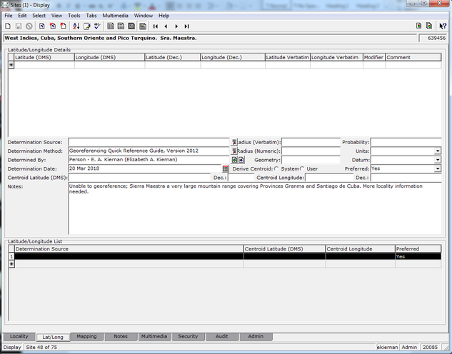
If unable to georeference (unable to pinpoint the locality or specimen is cultivated), this must be documented. Please include the georeferencer’s name, date, determination method (if applicable), and in the Notes field include reasoning as to why the location cannot be determined.

Notes Tab
This tab is to be used sparingly. Please ensure that the information entered into this field is pertinent to the Collection Event/Catalogue record(s) associated with that specific Sites record. Please also note that this field is not for the capture of georeferencing remarks, which are to be entered in the Lat/Long tab, Notes field.
GEOLocate Tab
Coming soon!